The village straggles for 2 miles along Catherington Lane from Causeway Farm in the south to White Dirt Farm and Downhouse Road in the north.
Its Church of Saxon and Norman origins has stood the test of time but its c20th Post Office, Newsagency, General Store and Butcher have all four now gone. And only one of the two original Public Houses – The Farmer – itself a replacement built in 1923 of a much earlier Inn – now remains.
The ‘core’ of the old village, consisting mainly of c18th brick and flint cottages, bounded by old flint garden walls and overhanging trees, extends only from Randalls Farm in the south to Butts Cottage in the north.
A walk up this section of Catherington Lane now, which was widened twice during the c20th, from its southern Civil Parish Ward boundary at Crouch Lane to its northern Ward boundary at White Dirt Lane reveals a mix of these older c18th dwellings and those mainly of the mid-c20th.
For example, most of the homes on the western side of Catherington Lane between Crouch Lane and Five Heads Road were built between WW1 (1914-1918) and WW2 (1939 – 1945). On the eastern side lie c18th Randalls Farm, restored after WW2, together with its adjacent cottages to the south.
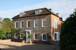
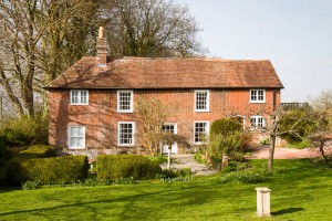
A little further north and bounding Five Heads Road is the c18th ‘Farm House’ (originally the extensive ‘Parsonage Farm’ – and known locally as ‘Wards Farm’ after its mid c20th owners). This was originally a two storey house with extensive cellars beneath and a semi-detached barn and a three-roomed cottage adjoining but now all have been joined together and a third storey added. Seven of its windows were bricked up upon the introduction of the Window Tax (late c18th) but have now been restored.
‘Ward’s Farm’ originally belonged to the Curtis family (who are commemorated in the Church) and Sir Roger Curtis, a Captain in the Royal Navy in the c19th, was Flag Captain to Lord Hood who lived in Catherington House (now Kingscourt School).
Catherington House was also originally a farm house, built in about 1750 by Sir Samuel Hood (1724-1816), who became an Irish Baron in 1782 as a result of his share of victory at the Battle of the Saintes and in 1786 became Commander-in-Chief Portsmouth. He called it his ‘little farmhouse at Catherington’ and used the roof to watch his frigates entering Spithead. He enlarged it almost to its present size in 1801. This roof, together with the Church tower roof, again became useful for Home Guard fire watching during the German bombing of WW2, especially during the Blitz of 1940 and 1941.
Among well-known visitors to Catherington House were Lord Nelson (for whom Hood was a mentor), Earl Howe, Mrs Kean (the wife of Edmund Kean the actor), the Younger Pitt, and Queen Caroline of Brunswick, the wife of King George IV.
A few rare trees still grow in the secluded garden and judging from their age must have been those that Lord Hood sent home as saplings from North America.
The ownership of Catherington House changed several times over the years but in 1921 it became a Retreat House for the Portsmouth Diocese and remained so until the late 1980s when it became Kingscourt (Preparatory) School. The House was requisitioned by the Army in both WW1 and WW2.
Five Heads Road which separates Ward’s Farm and Kingscourt School takes its name from the Norman tithe of ‘Five Hides’ (and multiples thereof) which referred, not to skins, but to areas available for pasture and plough, assessable for taxation.
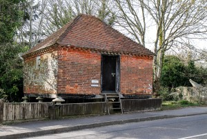
Opposite Ward’s Farm on the west side of Catherington Lane stands the original farm Granary (now in the ownership of Horndean Parish Council) and the totally demolished ruins of the original very large timber and thatch Tithe Barn and other ruined farm buildings.
Continuing northwards we find, on the left, the south-facing ‘Kinch’s Farm’ which takes its name from the family who lived there in c17th. The original thatched-roof farmhouse was destroyed by fire in 1945 but it remained as a family-run dairy farm, worked by the still local Prescott family, until the 1960s.
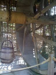
Nearby stood an outhouse which was fortunate not to have been destroyed in the 1945 fire. This contained a rare man-operated treadmill mentioned in a Deed of 1692 as the ‘Great Wheeled Well’. This was used to raise water, in a tapered bucket, containing about 5 gallons, from a depth of some 350’, which would have taken about 10 minutes to hoist.
The original wheel is now restored and features in the Weald & Downland Open Air Museum at Singleton near Chichester.
There was also a pond in the front of Kinch’s Farm but most of the other c18th houses in the village would have had rain-water cisterns with gravel filters. Mains water was not available in Catherington until 1928 and then from the Springs at Havant pumped from Lovedean to a closed reservoir adjacent to Butts Cottage.
West of Kinch’s Farm and winding downhill towards Lovedean is Roads Hill: so called because of the two ‘purrocks’ or ‘roads’ (areas of land) either side of it. Here, in the nearby woods, during the months prior to the ‘D-Day’ liberation of Normandy in June 1944, were encamped large numbers of Canadian troops.
West of Roads Hill is the Fairfield used since the 1950s as a permanent home by Travellers whose Caravans and Mobile Homes are tucked away behind its hedges. The families here organise many Funfairs during the year; the most local one being that to mark Guy Fawkes Day (5 November) when there is usually also a big bonfire in the fields between the Church and Catherington Lith, where the German V1 ‘doodlebug’ fell in 1944.
Continuing northwards and opposite Kinch’s Farm, we find on the eastern side of Catherington Lane the c17th ‘Farm Cottage’ and ‘Catherington Cottage’: both have magnificently secluded walled gardens to their east.
The dwellings between Farm Cottage and Catherington Cottage are early c21st.
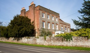
Opposite these cottages and behind its own flint-fronted wall lie the secluded gardens and grounds of the large house of St Catherine’s, built in the mid c19th by the Barnes family to replace its Elizabethan predecessor. We might think that here would have dwelt the ‘Squire’ of Catherington but, for those who lived in Catherington in the c18th/c19th and even later, the ‘Squire’ lived in Hinton Daubney, the large house across the valley to the west. The former Elizabethan House on that site had been the original home of the Royalist Hyde family who had assisted the later King Charles II in his escape to Shoreham after his defeat at the Battle or Worcester in 1651.
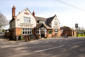
Proceeding further up Catherington Lane, we now reach the site of the two former Inns. On the west side, in Elizabethan times, stood the ‘Anchor’ or ‘Katryngton Inne’ which, in 1633 changed hands for £85 being bought by John Fie, a Surgeon from East Meon. By 1700, part of it was being used as a Smithy.
By this time the original ‘Farmer’ inn opposite must have become well established and, in addition to its main function as a tavern, there was a shop for groceries. But, as we have seen, even this old inn was demolished and rebuilt in 1923 and all the records of the old Inn were destroyed when the ‘Farrmer’ changed hands in 1958.
Opposite the present ‘Farmer Inn’ now stands the c18th ‘St Catherine’s Cottage’. This house was originally a group of three separate cottages for the senior domestic servants of the Barnes family at the adjacent St Catherines’s House. It too has an extensive walled garden.
What some of us still living (2015) may still remember as a working ‘Smithy’ is now converted into a dwelling at ‘The Old Forge’.
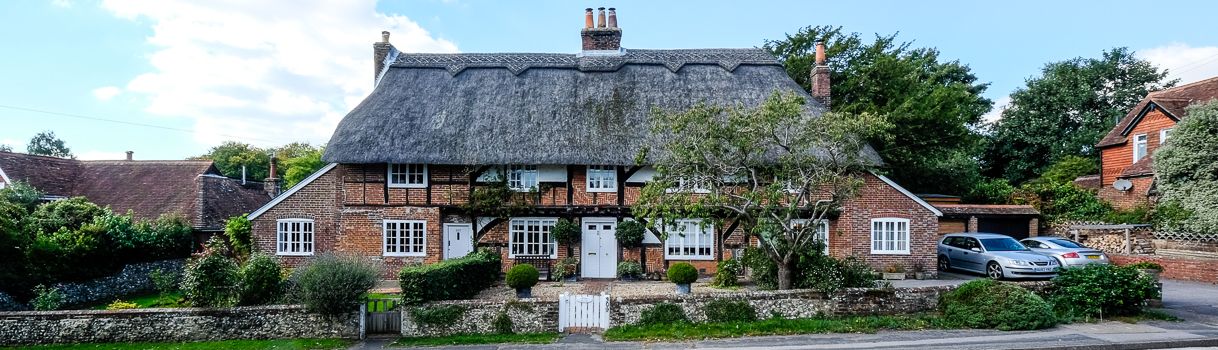
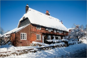
We now arrive at the magnificent picture-postcard ‘Tudor Cottages’ for which Catherington is best remembered. Thatched roof cottages such as these with timber frames and brick infilling are not uncommon in old Hampshire villages but they are unique to Catherington. They too originally accommodated the domestic servants of the nearby St Catherine’s House. Over the years, and despite being now ‘Listed’, they have been converted into a single dwelling; then to a pair of dwellings but have now reverted to the original three dwelling houses.
Opposite the Tudor Cottages is the Farmer Inn Meadow, the site of many former village Gatherings and Fetes which began during WW2 upon what is generally now identified as the Village Green.
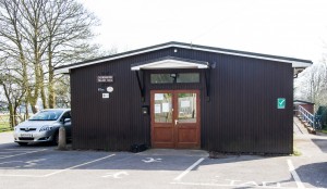
The Catherington Village Hall, built on land kindly leased from Gales, the then owners of the Brewery in Horndean, was finally erected in 1969 from funds slowly amassed from the series of Village Fetes held in the Farmer Inn Meadow. It has a capacity of about 60.
Two cottages, known as the School Cottages, were built opposite the School in late c19th.
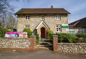
Here, on the eastern side of Catherington Lane stands the Village School. Built in 1852, probably on the site of an earlier school and under the auspices of the Church of England, it has for over 150 years cared for the children of Catherington: children who have grown up, married and sent their own children and grand-children to the school they loved. Originally, of course, it was a school for all ages, from infants to about age 14, the usual school-leaving age, at least until WW2. In more recent years it was much enlarged in a vernacular style and became a Primary School for a much wider local area but is now an Infants School. Until 1939 the Headmistress lived in the School House.
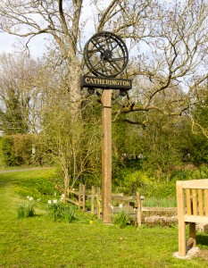
A commemorative Catherington Village Sign, featuring the iconic ‘Great Wheel’ as a motif, was erected in 1989 from funds raised by the ‘All Saints Friendship Group’ at a Village Festival in 1988. It is now in the ownership of Horndean Parish Council. A ‘Time Capsule’ from 1989 lies buried at its foot.
The track beside the pond gives access to the Cemetery under the management of East Hampshire District Council. This was established in about 1967 when the adjacent Catherington Churchyard became full. Even the Cemetery has been extended on several occasions and might over time grow even bigger as more local fields could be compulsorily purchased for this.
Opposite the cemetery lies Old School Field. During the 1960s this meadow was acquired by Hampshire County Council as a Playing Field for the Village School which, at that time, was a Primary School and the children used it for Rounders in the summer, Soccer in the winter, and for general recreation and athletics. However, the need for this ceased when the school became simply an Infants School. OSF was therefore redundant and its ownership was transferred from HCC to Horndean Parish Council. It is now used as a second Village Green.
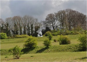
A footpath beside Old School Field leads westwards across the meadow of Parsonage Field, also in the ownership of Horndean Parish Council, to Catherington Down which is now a Site of Special Scientific Interest. Catherington Down is an area of isolated chalk grassland, with narrow fringing woodland belts, on west facing slopes. It was given to Hampshire County Council in 1963 by Captain The Hon Peter Long, a former owner of St Catherine’s House, on the condition that ‘it shall remain open land and terraces unbuilt upon and in its natural state and so encourage the flora and fauna’. The ancient strip lynchets on the Down have already been mentioned but the Down also contains a mass of wild flowers including rare wild orchids. It is much used for walking, especially by dog owners. And in times of snow by generations of children on sledges.
In 2011, the Down became included within the boundaries of the Southdowns National Park and although it remains in the ownership of HCC, it is actively managed by HPC.
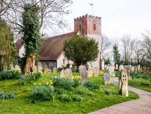
We now arrive at All Saints Church, which stands at the summit of Catherington Hill (421ft) and whose castellated tower is therefore a conspicuous landmark from many miles around.
There would, almost certainly, have been an earlier wooden Saxon church on this site but this was replaced by the present c12th Norman Church. We can but marvel at its construction, as we do at the Norman cathedrals, being built at a time when most of the village houses would have been of timber and even our Tudor Cottages, built 300 years later, are principally of a wood frame construction. But the parish of Catherington was then much bigger, extending from Butser to Waterlooville.
The church’s most famous feature must be the large c14th Wall Painting on the north side of the aisle representing the Archangel Michael weighing a soul in the balance. A devil is pulling down on one side while the Virgin Mary is exerting her influence on the other. Nothing changes!
There are traces of a further Wall Painting in the large Hyde Chapel just above the Jacobean tomb of Sir Nicholas Hyde from Hinton Daubney. He was the Chief Justice of the King’s Bench in the reign of King James I. We are lucky that such ancient wall paintings survived.
The remains of an ancient Churchyard Cross, now placed against the east end of the north aisle, was found partly buried beneath the path outside the West Door and partly built into the wall. It is thought to date from the c14th.
A more recent Churchyard Cross was erected as a memorial to Rear Admiral Sir Christopher Cradock (a frequent visitor to the Barnes family at St Catherine’s House) and his men who were killed in action on All Saints Day 1914 in a battle with superior German warships at Coronel off the Chilean coast in the first sea battle of WW1.
The Church tower was increased in height in 1750 to take a peal of 5 bells. A sixth was added in 1887 to commemorate the Golden Jubilee of HM Queen Victoria. And two more were added in about 2000 to commemorate Ann Sweeney, for many years a church Organist.
In 1881, the church was subjected to a ‘restoration‘of the usual c19th kind. It was subjected to a further ‘restoration’ in the 1960s; again one typical of the times. People might well wish that the church had been preserved in its original much simpler Norman style. And maybe the Saxons didn’t like the Norman ‘monstrosity’! But Christians would hold that it is the people IN the church who are important to God and not the church itself.
The Churchyard is large and many of its ancient tombstones lean and slope. The more notable tombs contain the bodies of Admiral Sir Charles Napier (‘Black Charlie’) 1786-1860, who lived at Merchistoun Hall; and of Edmund Kean, the actor.
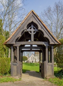
The Lych Gate, at the approach to the churchyard, was erected in 1923 as Memorial to those from the Parish and its surrounds who gave their lives in WW1 1914-1918. It contains 53 names. And this must represent a loss of some 25% of the local, mainly agricultural, manpower of the time.
Opposite the Lych Gate, Church House, the former Vicarage, mainly of flint, dates from the mid c19th but is built on the site of an earlier dwelling. This too enjoys an extensive garden to its west, protected on its north side by a brick wall and on its south by a hedgerow planted in 1782. At the garden’s western end stands a small copse of old beeches.
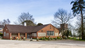
The Church Hall, adjacent to the Church was opened in 2000 and its cost was built partly from the proceeds of the sale of the former WW1 wooden hut used as a Church Hall for Horndean at the junction of Five Heads Road and London Road. The Hall stands on the site of a former meadow much of which now forms the Church Hall car park. It offers two Meeting Rooms, a large one for about 100 people and a smaller one for about a dozen. The 1960s Vicarage is adjacent.
Behind the church on Downland to the east lies the large field known as Turbary (Tarbery in some records) from which, in the Middle Ages, villagers had the right to cut turf for fuel. The delightful view here looks north-east to Windmill Hill (633 ft) and south to Langstone Harbour.
Walking north from the Lych Gate, we find, on the right, a track known locally as The Creek (it is very steep at its foot and consequently has a ‘crick’ in its descent). This in former times must simply have been a sheep or cattle drove. It now gives access to a covered Reservoir, owned by the Portsmouth Water Company. Built originally in 1928, when mains water was first provided, the Reservoir was much enlarged in 1989 to meet the greatly increased demands of new housing throughout the local area. Inside it resembles a Greek temple.
The Creek also gives access to the c18th Butts Cottage. This takes its name from the legal requirement in the c14th, c15th, and c16th for men between the ages of 14 and 60 to practise weekly with the Long Bow. It was usual to have the archery butts near a church so that men could attend Service and then go to their weekly exercise with the bow. It is a Long Bow shot in distance between the church and Butts Cottage. Hence the English successes at Crecy, Poitiers and Agincourt in the Hundred Years War.
The three houses on the western side of Catherington Lane at this point have all been enlarged or totally rebuilt since WW2 from earlier smaller dwellings. ‘Edge o’Beyond’ was originally built in about 1915 as the Officers Mess for two Officers when Catherington House had been requisitioned by the Army during WW1.
We now start our descent down Catherington Hill and, on the east side, beside the Copse, is a stone and wood bench. This was provided by villagers to mark the Coronation of HM Queen Elizabeth II in 1953. And its siting was determined by the need then to provide rest for those who were awaiting the 2-hourly bus service provided by Southdown between Clanfield and Portsmouth. There had been no bus service for Catherington until about 1952 and buses were withdrawn from the route in about 2012; being replaced by a request Taxi service.
All the houses north of Butts Cottage, whether along White Dirt Lane or down Catherington Hill and along Downhouse Road had their origins between WW1 and WW2 when country living became much easier and no planning restrictions applied. Many of these houses have in recent years been enlarged and aggrandised or simply demolished and replaced by larger houses.
White Dirt Lane, originally of course of chalk – dusty in summer and slimy in winter – led to the old turnpike coaching road between Portsmouth and London which ran through Horndean and Petersfield.
The original Catherington village Cricket ground existed where Glamorgan Road now runs. Catherington’s most famous cricketer was Thomas Brett (1747-1809). He played for the Hambledon Cricket Club and took part in the famous three-day match (two stump wickets and curved bats) on Broadhalfpenny Down beside the Bat & Ball Inn in June 1777 when they beat All England by an Innings and 168 runs. Brett took 8 wickets. ‘He was the fastest and straightest bowler that ever was known’.
Catherington’s most famous inhabitant, certainly in recent times, was probably Major (later Lieutenant Colonel) H G ‘Blondie’ Hasler, DSO, OBE, CdG, Royal Marines, who led the ‘Cockleshell Heroes’ Commando Raid by canoe upon German shipping in Bordeaux in 1942. He lived at Glyncorrig in Glamorgan Road and, after WW2, became a well-known international Yachtsman inventing what became known as the ‘Hasler Self-Steering Gear’ for solo ocean sailers.
Compiled from Notes made in 1949 by C R Evershed (1896-1953) which were subsequently edited, added to in respect of the Church and republished by Rev Christopher Beardsley, Incumbent of All Saints Church, in 1968. Copies of both the original Notes, which contain much more detail, and the later more comprehensive booklet about the Church, which was illustrated with pen & ink sketches, remain held by William Evershed, who has also updated the information covered above.