When the Romans landed at Portchester, they found Portsdown to be a bare turfy ridge. The first scouts to climb this chalk ridge saw only an unbroken stretch of forbidding dark forest reaching from their feet to the dim outlines of the hills nearly ten miles away. If they had come to these shores a thousand years earlier in Catherington history their view would have been of the same bare downs projecting from the thick primeval forest. But when they actually came to penetrate these woods, they found many patches of cultivation, especially on the higher ground.
The earlier tribes who had lived entirely as hunters and their successors who led a pastoral life with their herds on the hilltops had given place to those who tilled the soil as well as keeping livestock. These were the Celts who have left traces of their particular method of cultivation in the shape of terraces or lynchets on the slopes of the Downs throughout southern England. The lynchets on Catherington Down are rather wider than usual perhaps due to subsequent ploughing by the Saxons.
Catherington’s origins are found in the first known reference to the village where it is called CATERADAUNE, possibly a form of the British ‘Cat(h)-era-dun’ – People of the Hill Fort. Later spellings include ‘KATERINGETON’ (c12th), ‘KATERINGTON’ (C13th), ‘CATRINGTON’ (c15th) and ‘KATHERINGTON’ or ‘KATTERYNGTON (c16th).
Catherington is not mentioned in the Domesday Book of 1086 but was included under the heading of ‘Ceptune’ and formed part of the manor of Chalton until the end of that century.
As the population increased, so clearances were made in the woods and Clanfield (the ‘cleanly-felled’ place) emerged as a village. However the woods of beech and oak afforded ample food for the herds of pigs for which Hampshire has ever become famous.
As the forests were cleared and as more arable and pasture land became available, the countryside began to take on more and more of the appearance that it has today. Changes however were very gradual until the 1700s when the ‘Enclosures’ began and the huge open fields now became divided by quick-thorn hedges.
In the middle of the c18th, replacement plantations, mainly of beeches, began to be made and this work continued for rather more than a hundred years. The timber thus produced was widely used for c19th ship-building and, later for both WW1 and WW2.
Thus, except for rebuilding of farms and cottages here and there, little further alteration would be noticed for a long time.
A map drawn in 1816 is almost correct for conditions a hundred years later. The drift of population from rural industries to the factories had started. The numbers in the whole Parish of Catherington decreased from 1,199 in 1801 to 944 in 1831 and houses becoming empty or decayed were not rebuilt.
In 1919 came the complete reversal of this drift; not that rural industries had revived but that improvement in transport and the increasing availability of piped water, electricity and mains gas, made life in the country attractive to townsfolk.
In that year, large blocks of local land needed to be sold from the Clarke-Jervoise Estate at Idsworth House to meet the family’s three WW1 Death Duties. These blocks were then re-sold in small plots. Rapid development took place, bungalows and small houses springing up to meet the needs of those wishing to escape from the confines of the town. There were no Planning Controls until 1944.
Catherington Map Circa 1810

An unusual feature of this sub-division of the land was the erection in Catherington Lith of all sorts of huts and shacks as week-end and holiday retreats. These dwellings proved a wonderful boon as rural shelters to the owners and others when Portsmouth suffered so severely from the German Blitz bombing in 1940 and 1941.
So the village of Catherington has stood on its chalk spur of the South Downs for at least 2000 years. It still retains some of its erstwhile atmosphere of a tranquil rural oasis despite the tentacles of Greater Portsmouth’s suburban developments which have now surrounded the Village by much denser housing in Horndean in the east, Clanfield in the north, Lovedean in the south-west and Cowplain in the south.

Catherington enclosure awards 1816

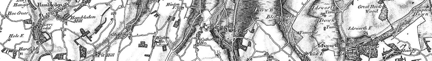
Catherington map 1870

Catherington map 1932
Compiled from Notes made in 1949 by C R Evershed (1896-1953) which were subsequently edited, added to in respect of the Church and republished by Rev Christopher Beardsley, Incumbent of All Saints Church, in 1968. Copies of both the original Notes, which contain much more detail, and the later more comprehensive booklet about the Church, which was illustrated with pen & ink sketches, remain held by William Evershed, who has also updated the information covered above.